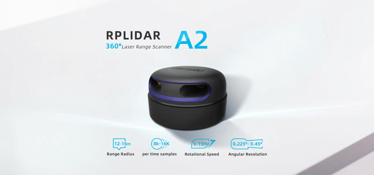
The RPLIDAR A2M12 is the 360 degree 2D laser scanner (LIDAR) solution developed by SLAMTEC. It can take up to 16000 samples of laser ranging per second thanks to its high rotation speed. The on-board system can perform 2D 360° scans within a range of 12 meters.
The core of RPLIDAR A2 runs clockwise to perform a 360 degree omnidirectional laser range scanning for its surrounding environment and then generate an outline map for the environment.
The RPLIDAR A2 consists of a range scanner core and mechanical powering parts which makes the core rotate at a high speed. When it functions normally, the scanner will rotate and scan clockwise allowing you to be able to get the range scan data via the communication interface of the RPLIDAR and control the start, stop and rotating speed of the rotation motor via PWM. The typical scanning frequency of the RPLIDAR A2 360° Laser Scanner is 10hz (600rpm) with an actual scanning frequency that can be freely adjusted within the 5-15hz range.
The RPLIDAR A2 adopts a laser triangulation measurement system developed by SLAMTEC, which makes the RPLIDAR A2 have excellent performance in multiple indoor and outdoor environments. With the low noise brushless motor and OPTMAG technology, the RPLIDAR has a ultra-long life.
SLAMTEC provides RoboStudio, a real-time monitoring tool and SDK (available for Windows, MacOS, x86 Linux and Arm Linux) to speed up the product development.
Specifications
Model: RPLDIAR-A2M12
Measuring Range: 0.2m - 12m
Sampling Frequency: 16K
Rotational Speed: 10Hz(5Hz-15Hz)
Angular Resolution: 0.225°
Scan Field Flatness: ±1.5°
Proof Level: Class 1
System Voltage: 5V
System Current: 450mA - 600mA
Power Consumption: 2.25W-3W
Output: UART Serial(256000bps)
Temperature Range: 0℃-40℃
Angular Range: 360°
Range Resolution: ≤1% of the range(≤12m) ≤2% of the range (12m~16m)
Accuracy: 1% of the range(≤3 m)2% of the range(3-5 m) 2.5% of the range(5-25m)
The core of RPLIDAR A2 runs clockwise to perform a 360-degree omnidirectional laser range scanning for its surrounding environment and then generate an outline map for the environment.
4cm Ultra-thin
With the custom special parts and the carefully designed internal mechanical system, the RPLIDAR A2 keeps its excellent performance while cut the thickness to only 4cm. It is ideal for all kinds of service robots.
The sample rate of LIDAR directly decides whether the robot can map quickly and accurately.
RPLIDAR improves the internal optical design and algorithm system to make the sample rate up to 8000 times, which is the highest in the current economical LIDAR industry.
360-degree laser range scanning
The core of RPLIDAR A2 runs clockwise to perform a 360-degree omnidirectional laser range scanning for its surrounding environment and then generate an outline map for the environment.
Low Noise, Brushless Motor New Non-contact Drive
Compared with the traditional belt drive mode, RPLIDAR A2 uses the self-designed brushless motor to reduce mechanical friction in running. Therefore, the RPLIDAR A2 can run smoothly without any noise.
16m/12m Range Radius
With algorithm optimization, RPLIDAR improves the range radius 16 meters, which will provide more data due to a larger environmental outline map.
OPTMAG Original Design
Most traditional non-solid LIDARs use slip ring to transfer power and data information, however, they only have thousands of hours of life due to mechanical wearing out. Slamtec has integrated wireless power and optical communication technology to self-design the OPTMAG technology, which breakouts the life limitation of the traditional LIDAR systems. It fixes the electrical connection failure caused by the physical wearing out so as to prolong the lifespan.
Safety Standard
The RPLIDAR A2 system adopts low-power infrared laser light as its light source and drives it by using modulated pulse. The laser emits light in a very short time frame which can ensure its safety for humans and pets. It has already reached the Class 1 Safety Standard.
Measures Distance Data 8000 Times Per Second
RPLIDAR A2 adopts the laser triangulation ranging principle, and with a high-speed RPVision3.0 range engine, it measures distance data 8000 times per second and also has excellent performance in a long distances.
Five years ultra-long life
With brushless motor and OPTMAG technology, the RPLIDAR will work for 5 years(24 hours every day).
Comparison of different versions
APPLICATIONS
The Secret for a Freely Walking Robot
Matched solution for robot autonomous localization and navigation
RPLIDAR A2 as the core sensor, can quickly get the outline infomation of the environment.
Integrating the RPLIDAR A2 with SLAMWARE in robot, the robot can build maps,autonomously,find path in real time and avoid obstacles automatically.
Multi-point Touch and Man-machine Interaction
Compared with traditional technology, with infrared laser device, the RPLIDAR A2 can realize the multi-point touch on a super-large screen, which has a higher resolution, reacts quickly and resists ambient light.
Robot simultaneous localization and mapping (SLAM)
3D printed parts are of low finish. Lot.of sharp edges on parts. Also the fitment of the parts are not happening because of excess material. Most often the parts have to be filed or reworked. Screws are given in exact number as needed. If one screw is missed, then the assembly is impossible
The consignment was not dispatched as per committed date and had to pursue for dispatch information. The courier didn,t deliver us despit lying in Jaipur and we had to personally collect it from Courier Hub adding to inconvenience. The logistics need to be improved. Just a feedback.
{"id":8257867284797,"title":"RPLIDAR A2M12 - 360 Degree LiDAR Laser Range Scanner (12m)","handle":"rplidar-a2m12-360-degree-lidar-laser-range-scanner-12m","description":"\u003cmeta charset=\"UTF-8\"\u003e\n\u003cp\u003eThe RPLIDAR A2M12 is the 360 degree 2D laser scanner (LIDAR) solution developed by SLAMTEC. It can take up to 16000 samples of laser ranging per second thanks to its high rotation speed. The on-board system can perform 2D 360° scans within a range of 12 meters.\u003c\/p\u003e\n\u003cp\u003eThe core of RPLIDAR A2 runs clockwise to perform a 360 degree omnidirectional laser range scanning for its surrounding environment and then generate an outline map for the environment.\u003c\/p\u003e\n\u003cp\u003eThe RPLIDAR A2 consists of a range scanner core and mechanical powering parts which makes the core rotate at a high speed. When it functions normally, the scanner will rotate and scan clockwise allowing you to be able to get the range scan data via the communication interface of the RPLIDAR and control the start, stop and rotating speed of the rotation motor via PWM. The typical scanning frequency of the RPLIDAR A2 360° Laser Scanner is 10hz (600rpm) with an actual scanning frequency that can be freely adjusted within the 5-15hz range.\u003c\/p\u003e\n\u003cp\u003eThe RPLIDAR A2 adopts a laser triangulation measurement system developed by SLAMTEC, which makes the RPLIDAR A2 have excellent performance in multiple indoor and outdoor environments. With the low noise brushless motor and OPTMAG technology, the RPLIDAR has a ultra-long life.\u003c\/p\u003e\n\u003cp\u003eSLAMTEC provides RoboStudio, a real-time monitoring tool and SDK (available for Windows, MacOS, x86 Linux and Arm Linux) to speed up the product development.\u003c\/p\u003e\n\u003cp\u003e \u003c\/p\u003e\n\u003ch2\u003eSpecifications\u003c\/h2\u003e\n\u003cdiv class=\"desCon\"\u003e\n\u003cul\u003e\n\u003cli\u003eModel: RPLDIAR-A2M12\u003c\/li\u003e\n\u003cli\u003eMeasuring Range: 0.2m - 12m\u003c\/li\u003e\n\u003cli\u003eSampling Frequency: 16K\u003c\/li\u003e\n\u003cli\u003eRotational Speed: 10Hz(5Hz-15Hz)\u003c\/li\u003e\n\u003cli\u003eAngular Resolution: 0.225°\u003c\/li\u003e\n\u003cli\u003eScan Field Flatness: ±1.5°\u003c\/li\u003e\n\u003cli\u003eProof Level: Class 1\u003c\/li\u003e\n\u003cli\u003eSystem Voltage: 5V\u003c\/li\u003e\n\u003cli\u003eSystem Current: 450mA - 600mA\u003c\/li\u003e\n\u003cli\u003ePower Consumption: 2.25W-3W\u003c\/li\u003e\n\u003cli\u003eOutput: UART Serial(256000bps)\u003c\/li\u003e\n\u003cli\u003eTemperature Range: 0℃-40℃\u003c\/li\u003e\n\u003cli\u003eAngular Range: 360°\u003c\/li\u003e\n\u003cli\u003eRange Resolution: ≤1% of the range(≤12m) ≤2% of the range (12m~16m)\u003c\/li\u003e\n\u003cli\u003eAccuracy: 1% of the range(≤3 m)2% of the range(3-5 m) 2.5% of the range(5-25m)\u003c\/li\u003e\n\u003c\/ul\u003e\n\u003cp\u003e \u003c\/p\u003e\n\u003c\/div\u003e\n\u003ch2\u003eDocuments \u0026amp; Resources\u003cbr\u003e\n\u003c\/h2\u003e\n\u003cdiv class=\"desCon\"\u003e\n\u003cul\u003e\n\u003cli\u003e\u003ca href=\"https:\/\/bucket-download.slamtec.com\/f65f8e37026796c56ddd512d33c7d4308d9edf94\/LD310_SLAMTEC_rplidar_datasheet_A2M12_v1.0_en.pdf\" rel=\"nofollow noopener noreferrer\" target=\"_blank\"\u003eSLAMTEC Datasheet\u003c\/a\u003e\u003c\/li\u003e\n\u003cli\u003e\u003ca href=\"https:\/\/www.slamtec.com\/en\/Support#rplidar-a-series\" rel=\"nofollow noopener noreferrer\" target=\"_blank\"\u003eDownload Center\u003c\/a\u003e\u003c\/li\u003e\n\u003cli\u003e\u003ca href=\"https:\/\/www.dfrobot.com\/forum\/topic\/320253\" target=\"_blank\" rel=\"noopener noreferrer\"\u003eFAQ about LiDAR\u003c\/a\u003e\u003c\/li\u003e\n\u003c\/ul\u003e\n\u003cp\u003e \u003c\/p\u003e\n\u003c\/div\u003e\n\u003cdiv style=\"text-align: center;\"\u003e\u003cimg src=\"https:\/\/image.dfrobot.com\/image\/cache3\/data\/DFR0445\/1.png\" alt=\"RPLIDAR A2M12 - 360 Degree LiDAR (12m,5Hz-15Hz)\" style=\"float: none;\"\u003e\u003c\/div\u003e\n\u003cdiv style=\"text-align: center;\" class=\"desCon\"\u003e\n\u003cp style=\"text-align: center;\"\u003eThe core of RPLIDAR A2 runs clockwise to perform a 360-degree omnidirectional laser range scanning for its surrounding environment and then generate an outline map for the environment. \u003cbr\u003e\u003c\/p\u003e\n\u003cp\u003e\u003cimg style=\"float: none;\" src=\"https:\/\/image.dfrobot.com\/image\/cache3\/data\/DFR0445\/2.png\" title=\"RPLIDAR A2M12 - 360 Degree Laser LiDAR Operating Principle\" alt=\"RPLIDAR A2M12 - 360 Degree Laser LiDAR Operating Principle\" original=\"https:\/\/image.dfrobot.com\/image\/cache3\/data\/DFR0445\/2.png\"\u003e\u003c\/p\u003e\n\u003cp\u003e\u003cb\u003e\u003cbr\u003e\u003c\/b\u003e\u003c\/p\u003e\n\u003cp\u003e\u003cb\u003e4cm Ultra-thin\u003c\/b\u003e\u003c\/p\u003e\n\u003cp\u003eWith the custom special parts and the carefully designed internal mechanical system, the RPLIDAR A2 keeps its excellent performance while cut the thickness to only 4cm. It is ideal for all kinds of service robots. \u003cbr\u003e\u003c\/p\u003e\n\u003cp\u003e\u003cimg src=\"https:\/\/image.dfrobot.com\/image\/cache3\/data\/DFR0445\/3.png\" title=\"RPLIDAR A2M12 - 360 Degree Laser LiDAR 4cm Ultra-thin\" alt=\"RPLIDAR A2M12 - 360 Degree Laser LiDAR 4cm Ultra-thin\" original=\"https:\/\/image.dfrobot.com\/image\/cache3\/data\/DFR0445\/3.png\"\u003e\u003cbr\u003e\u003c\/p\u003e\n\u003cp\u003eThe sample rate of LIDAR directly decides whether the robot can map quickly and accurately.\u003c\/p\u003e\n\u003cp\u003eRPLIDAR improves the internal optical design and algorithm system to make the sample rate up to 8000 times, which is the highest in the current economical LIDAR industry.\u003c\/p\u003e\n\u003cp\u003e\u003cimg src=\"https:\/\/image.dfrobot.com\/image\/cache3\/data\/DFR0445\/4.png\" title=\"RPLIDAR A2M12 - 360 Degree Laser LiDAR Comparison under Different Conditions\" alt=\"RPLIDAR A2M12 - 360 Degree Laser LiDAR Comparison under Different Conditions\" style=\"float: none;\" original=\"https:\/\/image.dfrobot.com\/image\/cache3\/data\/DFR0445\/4.png\"\u003e\u003c\/p\u003e\n\u003cp\u003e\u003cb\u003e\u003cbr\u003e\u003c\/b\u003e\u003c\/p\u003e\n\u003cp\u003e\u003cb\u003e360-degree laser range scanning\u003c\/b\u003e\u003c\/p\u003e\n\u003cp\u003eThe core of RPLIDAR A2 runs clockwise to perform a 360-degree omnidirectional laser range scanning for its surrounding environment and then generate an outline map for the environment.\u003c\/p\u003e\n\u003cp\u003e\u003cimg src=\"https:\/\/image.dfrobot.com\/image\/cache3\/data\/DFR0445\/5.png\" title=\"RPLIDAR A2M12 - 360-Degree Laser Range Scanning\" alt=\"RPLIDAR A2M12 - 360-degree Laser Range Scanning\" original=\"https:\/\/image.dfrobot.com\/image\/cache3\/data\/DFR0445\/5.png\"\u003e\u003c\/p\u003e\n\u003cp\u003e\u003cb\u003e\u003cbr\u003e\u003c\/b\u003e\u003c\/p\u003e\n\u003cp\u003e\u003cb\u003eLow Noise, Brushless Motor New Non-contact Drive \u003c\/b\u003e\u003c\/p\u003e\n\u003cp\u003eCompared with the traditional belt drive mode, RPLIDAR A2 uses the self-designed brushless motor to reduce mechanical friction in running. Therefore, the RPLIDAR A2 can run smoothly without any noise.\u003c\/p\u003e\n\u003cp\u003e\u003cimg src=\"https:\/\/image.dfrobot.com\/image\/cache3\/data\/DFR0445\/6.png\" title=\"RPLIDAR A2M12 - 360 Degree LiDAR Low Noise, Brushless Motor\" alt=\"RPLIDAR A2M12 - 360 Degree LiDAR Low Noise, Brushless Motor\" original=\"https:\/\/image.dfrobot.com\/image\/cache3\/data\/DFR0445\/6.png\"\u003e\u003c\/p\u003e\n\u003cp\u003e\u003cb\u003e\u003cbr\u003e\u003c\/b\u003e\u003c\/p\u003e\n\u003cp\u003e\u003cb\u003e16m\/12m Range Radius \u003c\/b\u003e\u003c\/p\u003e\n\u003cp\u003eWith algorithm optimization, RPLIDAR improves the range radius 16 meters, which will provide more data due to a larger environmental outline map.\u003c\/p\u003e\n\u003cp\u003e\u003cimg src=\"https:\/\/image.dfrobot.com\/image\/cache3\/data\/DFR0445\/7.png\" title=\"RPLIDAR A2M12 - 360 Degree LiDAR Range Radius:16m\/12m\" alt=\"RPLIDAR A2M12 - 360 Degree LiDAR Range Radius:16m\/12m\" original=\"https:\/\/image.dfrobot.com\/image\/cache3\/data\/DFR0445\/7.png\"\u003e\u003c\/p\u003e\n\u003cp\u003e\u003cb\u003e\u003cbr\u003e\u003c\/b\u003e\u003c\/p\u003e\n\u003cp\u003e\u003cb\u003eOPTMAG Original Design \u003c\/b\u003e\u003c\/p\u003e\n\u003cp\u003eMost traditional non-solid LIDARs use slip ring to transfer power and data information, however, they only have thousands of hours of life due to mechanical wearing out. Slamtec has integrated wireless power and optical communication technology to self-design the OPTMAG technology, which breakouts the life limitation of the traditional LIDAR systems. It fixes the electrical connection failure caused by the physical wearing out so as to prolong the lifespan.\u003c\/p\u003e\n\u003cp\u003e\u003cimg src=\"https:\/\/image.dfrobot.com\/image\/cache3\/data\/DFR0445\/8.png\" title=\"RPLIDAR A2M12 - 360 Degree LiDAR OPTMAG Original Design\" alt=\"RPLIDAR A2M12 - 360 Degree LiDAR OPTMAG Original Design\" original=\"https:\/\/image.dfrobot.com\/image\/cache3\/data\/DFR0445\/8.png\"\u003e\u003c\/p\u003e\n\u003cp\u003e\u003cb\u003e\u003cbr\u003e\u003c\/b\u003e\u003c\/p\u003e\n\u003cp\u003e\u003cb\u003eSafety Standard\u003c\/b\u003e\u003c\/p\u003e\n\u003cp\u003eThe RPLIDAR A2 system adopts low-power infrared laser light as its light source and drives it by using modulated pulse. The laser emits light in a very short time frame which can ensure its safety for humans and pets. It has already reached the Class 1 Safety Standard.\u003c\/p\u003e\n\u003cp\u003e\u003cimg src=\"https:\/\/image.dfrobot.com\/image\/cache3\/data\/DFR0445\/9.png\" title=\"RPLIDAR A2M12 - 360 Degree LiDAR Safety Standard: Class 1\" alt=\"RPLIDAR A2M12 - 360 Degree LiDAR Safety Standard: Class 1\" original=\"https:\/\/image.dfrobot.com\/image\/cache3\/data\/DFR0445\/9.png\"\u003e\u003c\/p\u003e\n\u003cp\u003e\u003cb\u003e\u003cbr\u003e\u003c\/b\u003e\u003c\/p\u003e\n\u003cp\u003e\u003cb\u003eMeasures Distance Data 8000 Times Per Second\u003c\/b\u003e\u003cbr\u003e\u003c\/p\u003e\n\u003cp\u003eRPLIDAR A2 adopts the laser triangulation ranging principle, and with a high-speed RPVision3.0 range engine, it measures distance data 8000 times per second and also has excellent performance in a long distances.\u003c\/p\u003e\n\u003cp\u003e\u003cimg src=\"https:\/\/image.dfrobot.com\/image\/cache3\/data\/DFR0445\/10.png\" title=\"RPLIDAR A2M12 - 360 Degree LiDAR Measures Distance Data 8000 times per second\" alt=\"RPLIDAR A2M12 - 360 Degree LiDAR Measures Distance Data 8000 times per second\" original=\"https:\/\/image.dfrobot.com\/image\/cache3\/data\/DFR0445\/10.png\"\u003e\u003c\/p\u003e\n\u003cp\u003e\u003cb\u003e\u003cbr\u003e\u003c\/b\u003e\u003c\/p\u003e\n\u003ch3\u003e\u003cb\u003eFive years ultra-long life\u003c\/b\u003e\u003c\/h3\u003e\n\u003cp\u003e With brushless motor and OPTMAG technology, the RPLIDAR will work for 5 years(24 hours every day).\u003c\/p\u003e\n\u003cdiv\u003e\n\u003cimg src=\"https:\/\/image.dfrobot.com\/image\/cache3\/data\/DFR0445\/11.png\" title=\"RPLIDAR A2M12 - 360 Degree LiDAR Five Years Life\" alt=\"RPLIDAR A2M12 - 360 Degree LiDAR Five Years Life\" original=\"https:\/\/image.dfrobot.com\/image\/cache3\/data\/DFR0445\/11.png\"\u003e \u003c\/div\u003e\n\u003ch2\u003e\u003cb\u003e \u003c\/b\u003e\u003c\/h2\u003e\n\u003ch2\u003e\u003cb\u003eComparison of different versions\u003c\/b\u003e\u003c\/h2\u003e\n\u003cp\u003e\u003cimg src=\"https:\/\/image.dfrobot.com\/image\/cache3\/data\/DFR0445\/12.png\" title=\"RPLIDAR Parameter comparison of different versions\" alt=\"RPLIDAR Parameter comparison of different versions\" original=\"https:\/\/image.dfrobot.com\/image\/cache3\/data\/DFR0445\/12.png\"\u003e\u003c\/p\u003e\n\u003c\/div\u003e\n\u003ch2\u003e \u003c\/h2\u003e\n\u003cdiv style=\"text-align: center;\"\u003eAPPLICATIONS\u003c\/div\u003e\n\u003cdiv class=\"desCon\"\u003e\n\u003ch3 style=\"text-align: center;\"\u003e\u003cb\u003eThe Secret for a Freely Walking Robot\u003c\/b\u003e\u003c\/h3\u003e\n\u003cp style=\"text-align: center;\"\u003eMatched solution for robot autonomous localization and navigation\u003c\/p\u003e\n\u003cp style=\"text-align: center;\"\u003eRPLIDAR A2 as the core sensor, can quickly get the outline infomation of the environment.\u003c\/p\u003e\n\u003cp style=\"text-align: center;\"\u003eIntegrating the RPLIDAR A2 with SLAMWARE in robot, the robot can build maps,autonomously,find path in real time and avoid obstacles automatically.\u003c\/p\u003e\n\u003cp style=\"text-align: center;\"\u003e\u003cimg src=\"https:\/\/image.dfrobot.com\/image\/data\/DFR0445\/200820%20Update\/Application\/ipad-A2-apply-banner.png\" title=\"RPLIDAR A2M12 - 360 Degree Laser Scanner Application: robot autonomous localization and navigation\" alt=\"RPLIDAR A2M12 - 360 Degree Laser Scanner Application: robot autonomous localization and navigation\" original=\"https:\/\/image.dfrobot.com\/image\/data\/DFR0445\/200820 Update\/Application\/ipad-A2-apply-banner.png\"\u003e\u003c\/p\u003e\n\u003cp style=\"text-align: center;\"\u003e \u003cbr\u003e\u003c\/p\u003e\n\u003ctable style=\"width: 80%; margin: auto;\"\u003e\n\u003ctbody\u003e\n\u003ctr\u003e\n\u003ctd style=\"text-align: center; border: 0px;\" colspan=\"2\"\u003e\n\u003ch2\u003eMulti-point Touch and Man-machine Interaction\u003c\/h2\u003e\n\u003cp style=\"text-align: center;\"\u003eCompared with traditional technology, with infrared laser device, the RPLIDAR A2 can realize the multi-point touch on a super-large screen, which has a higher resolution, reacts quickly and resists ambient light.\u003c\/p\u003e\n\u003c\/td\u003e\n\u003c\/tr\u003e\n\u003ctr\u003e\n\u003ctd style=\"text-align: center; border: 0px;\"\u003e\n\u003cimg src=\"https:\/\/image.dfrobot.com\/image\/data\/DFR0445\/200820%20Update\/Application\/slam-min.gif\" title=\"RPLIDAR A2M12 Robot simultaneous localization and mapping\" alt=\"RPLIDAR A2M12 Robot simultaneous localization and mapping\" original=\"https:\/\/image.dfrobot.com\/image\/data\/DFR0445\/200820 Update\/Application\/slam-min.gif\"\u003e\n\u003cp style=\"text-align: center;\"\u003eRobot simultaneous localization and mapping (SLAM)\u003c\/p\u003e\n\u003c\/td\u003e\n\u003ctd style=\"text-align: center; border: 0px;\"\u003e\n\u003cimg src=\"https:\/\/image.dfrobot.com\/image\/data\/DFR0445\/200820%20Update\/Application\/3d-rebuild-min.gif\" title=\"RPLIDAR A2M12 Environment scanning and 3D rebuilding\" alt=\"RPLIDAR A2M12 Environment scanning and 3D rebuilding\" original=\"https:\/\/image.dfrobot.com\/image\/data\/DFR0445\/200820 Update\/Application\/3d-rebuild-min.gif\"\u003e\n\u003cp style=\"text-align: center;\"\u003eEnvironment scanning and 3D rebuilding\u003c\/p\u003e\n\u003c\/td\u003e\n\u003c\/tr\u003e\n\u003ctr\u003e\n\u003ctd style=\"text-align: center; border: 0px;\"\u003e\n\u003cimg src=\"https:\/\/image.dfrobot.com\/image\/data\/DFR0445\/200820%20Update\/Application\/apply-video3.png\" title=\"RPLIDAR A2M12 Obstacle detecting and avoiding\" alt=\"RPLIDAR A2M12 Obstacle detecting and avoiding\" original=\"https:\/\/image.dfrobot.com\/image\/data\/DFR0445\/200820 Update\/Application\/apply-video3.png\"\u003e\n\u003cp style=\"text-align: center;\"\u003eObstacle detecting and avoiding\u003c\/p\u003e\n\u003c\/td\u003e\n\u003ctd style=\"text-align: center; border: 0px;\"\u003e\n\u003cimg src=\"https:\/\/image.dfrobot.com\/image\/data\/DFR0445\/200820%20Update\/Application\/touch-min.gif\" title=\"RPLIDAR A2M12 Multi-point touching and man-mechine interaction\" alt=\"RPLIDAR A2M12 Multi-point touching and man-mechine interaction\" original=\"https:\/\/image.dfrobot.com\/image\/data\/DFR0445\/200820 Update\/Application\/touch-min.gif\"\u003e\n\u003cp style=\"text-align: center;\"\u003eMulti-point touching and man-mechine interaction\u003c\/p\u003e\n\u003c\/td\u003e\n\u003c\/tr\u003e\n\u003c\/tbody\u003e\n\u003c\/table\u003e\n\u003ch4\u003e\n\u003cbr\u003e\u003cbr\u003e\n\u003c\/h4\u003e\n\u003ch4\u003eSHIPPING LIST\u003c\/h4\u003e\n\u003cdiv class=\"desCon\"\u003e\n\u003cli\u003eRPLIDAR A2M12 - 360 Degree Laser Range Scanner x1\u003c\/li\u003e\n\u003c\/div\u003e\n\u003c\/div\u003e","published_at":"2023-05-01T12:19:47+05:30","created_at":"2023-05-01T12:19:47+05:30","vendor":"SLAMTEC","type":"","tags":["ELC1","LIDAR sensor","LIDAR-MOD","SLTC","ZOHO UPDATED"],"price":2499999,"price_min":2499999,"price_max":2499999,"available":false,"price_varies":false,"compare_at_price":2699999,"compare_at_price_min":2699999,"compare_at_price_max":2699999,"compare_at_price_varies":false,"variants":[{"id":45105728618813,"title":"Default Title","option1":"Default Title","option2":null,"option3":null,"sku":"ELC1130","requires_shipping":true,"taxable":true,"featured_image":null,"available":false,"name":"RPLIDAR A2M12 - 360 Degree LiDAR Laser Range Scanner (12m)","public_title":null,"options":["Default Title"],"price":2499999,"weight":250,"compare_at_price":2699999,"inventory_management":"shopify","barcode":"ELC1130","requires_selling_plan":false,"selling_plan_allocations":[],"quantity_rule":{"min":1,"max":null,"increment":1}}],"images":["\/\/thinkrobotics.com\/cdn\/shop\/files\/H1139db010e0d444489857722b30999b1X.jpg?v=1682925926","\/\/thinkrobotics.com\/cdn\/shop\/files\/16597_2.jpg?v=1682926117"],"featured_image":"\/\/thinkrobotics.com\/cdn\/shop\/files\/H1139db010e0d444489857722b30999b1X.jpg?v=1682925926","options":["Title"],"media":[{"alt":"RPLIDAR A2M12-360 Degree LiDAR Laser Range Scanner Online","id":33471595839805,"position":1,"preview_image":{"aspect_ratio":1.0,"height":800,"width":800,"src":"\/\/thinkrobotics.com\/cdn\/shop\/files\/H1139db010e0d444489857722b30999b1X.jpg?v=1682925926"},"aspect_ratio":1.0,"height":800,"media_type":"image","src":"\/\/thinkrobotics.com\/cdn\/shop\/files\/H1139db010e0d444489857722b30999b1X.jpg?v=1682925926","width":800},{"alt":"RPLIDAR A2M12-360 Degree LiDAR Laser Range Scanner Online","id":33471614288189,"position":2,"preview_image":{"aspect_ratio":1.0,"height":1080,"width":1080,"src":"\/\/thinkrobotics.com\/cdn\/shop\/files\/16597_2.jpg?v=1682926117"},"aspect_ratio":1.0,"height":1080,"media_type":"image","src":"\/\/thinkrobotics.com\/cdn\/shop\/files\/16597_2.jpg?v=1682926117","width":1080}],"requires_selling_plan":false,"selling_plan_groups":[],"content":"\u003cmeta charset=\"UTF-8\"\u003e\n\u003cp\u003eThe RPLIDAR A2M12 is the 360 degree 2D laser scanner (LIDAR) solution developed by SLAMTEC. It can take up to 16000 samples of laser ranging per second thanks to its high rotation speed. The on-board system can perform 2D 360° scans within a range of 12 meters.\u003c\/p\u003e\n\u003cp\u003eThe core of RPLIDAR A2 runs clockwise to perform a 360 degree omnidirectional laser range scanning for its surrounding environment and then generate an outline map for the environment.\u003c\/p\u003e\n\u003cp\u003eThe RPLIDAR A2 consists of a range scanner core and mechanical powering parts which makes the core rotate at a high speed. When it functions normally, the scanner will rotate and scan clockwise allowing you to be able to get the range scan data via the communication interface of the RPLIDAR and control the start, stop and rotating speed of the rotation motor via PWM. The typical scanning frequency of the RPLIDAR A2 360° Laser Scanner is 10hz (600rpm) with an actual scanning frequency that can be freely adjusted within the 5-15hz range.\u003c\/p\u003e\n\u003cp\u003eThe RPLIDAR A2 adopts a laser triangulation measurement system developed by SLAMTEC, which makes the RPLIDAR A2 have excellent performance in multiple indoor and outdoor environments. With the low noise brushless motor and OPTMAG technology, the RPLIDAR has a ultra-long life.\u003c\/p\u003e\n\u003cp\u003eSLAMTEC provides RoboStudio, a real-time monitoring tool and SDK (available for Windows, MacOS, x86 Linux and Arm Linux) to speed up the product development.\u003c\/p\u003e\n\u003cp\u003e \u003c\/p\u003e\n\u003ch2\u003eSpecifications\u003c\/h2\u003e\n\u003cdiv class=\"desCon\"\u003e\n\u003cul\u003e\n\u003cli\u003eModel: RPLDIAR-A2M12\u003c\/li\u003e\n\u003cli\u003eMeasuring Range: 0.2m - 12m\u003c\/li\u003e\n\u003cli\u003eSampling Frequency: 16K\u003c\/li\u003e\n\u003cli\u003eRotational Speed: 10Hz(5Hz-15Hz)\u003c\/li\u003e\n\u003cli\u003eAngular Resolution: 0.225°\u003c\/li\u003e\n\u003cli\u003eScan Field Flatness: ±1.5°\u003c\/li\u003e\n\u003cli\u003eProof Level: Class 1\u003c\/li\u003e\n\u003cli\u003eSystem Voltage: 5V\u003c\/li\u003e\n\u003cli\u003eSystem Current: 450mA - 600mA\u003c\/li\u003e\n\u003cli\u003ePower Consumption: 2.25W-3W\u003c\/li\u003e\n\u003cli\u003eOutput: UART Serial(256000bps)\u003c\/li\u003e\n\u003cli\u003eTemperature Range: 0℃-40℃\u003c\/li\u003e\n\u003cli\u003eAngular Range: 360°\u003c\/li\u003e\n\u003cli\u003eRange Resolution: ≤1% of the range(≤12m) ≤2% of the range (12m~16m)\u003c\/li\u003e\n\u003cli\u003eAccuracy: 1% of the range(≤3 m)2% of the range(3-5 m) 2.5% of the range(5-25m)\u003c\/li\u003e\n\u003c\/ul\u003e\n\u003cp\u003e \u003c\/p\u003e\n\u003c\/div\u003e\n\u003ch2\u003eDocuments \u0026amp; Resources\u003cbr\u003e\n\u003c\/h2\u003e\n\u003cdiv class=\"desCon\"\u003e\n\u003cul\u003e\n\u003cli\u003e\u003ca href=\"https:\/\/bucket-download.slamtec.com\/f65f8e37026796c56ddd512d33c7d4308d9edf94\/LD310_SLAMTEC_rplidar_datasheet_A2M12_v1.0_en.pdf\" rel=\"nofollow noopener noreferrer\" target=\"_blank\"\u003eSLAMTEC Datasheet\u003c\/a\u003e\u003c\/li\u003e\n\u003cli\u003e\u003ca href=\"https:\/\/www.slamtec.com\/en\/Support#rplidar-a-series\" rel=\"nofollow noopener noreferrer\" target=\"_blank\"\u003eDownload Center\u003c\/a\u003e\u003c\/li\u003e\n\u003cli\u003e\u003ca href=\"https:\/\/www.dfrobot.com\/forum\/topic\/320253\" target=\"_blank\" rel=\"noopener noreferrer\"\u003eFAQ about LiDAR\u003c\/a\u003e\u003c\/li\u003e\n\u003c\/ul\u003e\n\u003cp\u003e \u003c\/p\u003e\n\u003c\/div\u003e\n\u003cdiv style=\"text-align: center;\"\u003e\u003cimg src=\"https:\/\/image.dfrobot.com\/image\/cache3\/data\/DFR0445\/1.png\" alt=\"RPLIDAR A2M12 - 360 Degree LiDAR (12m,5Hz-15Hz)\" style=\"float: none;\"\u003e\u003c\/div\u003e\n\u003cdiv style=\"text-align: center;\" class=\"desCon\"\u003e\n\u003cp style=\"text-align: center;\"\u003eThe core of RPLIDAR A2 runs clockwise to perform a 360-degree omnidirectional laser range scanning for its surrounding environment and then generate an outline map for the environment. \u003cbr\u003e\u003c\/p\u003e\n\u003cp\u003e\u003cimg style=\"float: none;\" src=\"https:\/\/image.dfrobot.com\/image\/cache3\/data\/DFR0445\/2.png\" title=\"RPLIDAR A2M12 - 360 Degree Laser LiDAR Operating Principle\" alt=\"RPLIDAR A2M12 - 360 Degree Laser LiDAR Operating Principle\" original=\"https:\/\/image.dfrobot.com\/image\/cache3\/data\/DFR0445\/2.png\"\u003e\u003c\/p\u003e\n\u003cp\u003e\u003cb\u003e\u003cbr\u003e\u003c\/b\u003e\u003c\/p\u003e\n\u003cp\u003e\u003cb\u003e4cm Ultra-thin\u003c\/b\u003e\u003c\/p\u003e\n\u003cp\u003eWith the custom special parts and the carefully designed internal mechanical system, the RPLIDAR A2 keeps its excellent performance while cut the thickness to only 4cm. It is ideal for all kinds of service robots. \u003cbr\u003e\u003c\/p\u003e\n\u003cp\u003e\u003cimg src=\"https:\/\/image.dfrobot.com\/image\/cache3\/data\/DFR0445\/3.png\" title=\"RPLIDAR A2M12 - 360 Degree Laser LiDAR 4cm Ultra-thin\" alt=\"RPLIDAR A2M12 - 360 Degree Laser LiDAR 4cm Ultra-thin\" original=\"https:\/\/image.dfrobot.com\/image\/cache3\/data\/DFR0445\/3.png\"\u003e\u003cbr\u003e\u003c\/p\u003e\n\u003cp\u003eThe sample rate of LIDAR directly decides whether the robot can map quickly and accurately.\u003c\/p\u003e\n\u003cp\u003eRPLIDAR improves the internal optical design and algorithm system to make the sample rate up to 8000 times, which is the highest in the current economical LIDAR industry.\u003c\/p\u003e\n\u003cp\u003e\u003cimg src=\"https:\/\/image.dfrobot.com\/image\/cache3\/data\/DFR0445\/4.png\" title=\"RPLIDAR A2M12 - 360 Degree Laser LiDAR Comparison under Different Conditions\" alt=\"RPLIDAR A2M12 - 360 Degree Laser LiDAR Comparison under Different Conditions\" style=\"float: none;\" original=\"https:\/\/image.dfrobot.com\/image\/cache3\/data\/DFR0445\/4.png\"\u003e\u003c\/p\u003e\n\u003cp\u003e\u003cb\u003e\u003cbr\u003e\u003c\/b\u003e\u003c\/p\u003e\n\u003cp\u003e\u003cb\u003e360-degree laser range scanning\u003c\/b\u003e\u003c\/p\u003e\n\u003cp\u003eThe core of RPLIDAR A2 runs clockwise to perform a 360-degree omnidirectional laser range scanning for its surrounding environment and then generate an outline map for the environment.\u003c\/p\u003e\n\u003cp\u003e\u003cimg src=\"https:\/\/image.dfrobot.com\/image\/cache3\/data\/DFR0445\/5.png\" title=\"RPLIDAR A2M12 - 360-Degree Laser Range Scanning\" alt=\"RPLIDAR A2M12 - 360-degree Laser Range Scanning\" original=\"https:\/\/image.dfrobot.com\/image\/cache3\/data\/DFR0445\/5.png\"\u003e\u003c\/p\u003e\n\u003cp\u003e\u003cb\u003e\u003cbr\u003e\u003c\/b\u003e\u003c\/p\u003e\n\u003cp\u003e\u003cb\u003eLow Noise, Brushless Motor New Non-contact Drive \u003c\/b\u003e\u003c\/p\u003e\n\u003cp\u003eCompared with the traditional belt drive mode, RPLIDAR A2 uses the self-designed brushless motor to reduce mechanical friction in running. Therefore, the RPLIDAR A2 can run smoothly without any noise.\u003c\/p\u003e\n\u003cp\u003e\u003cimg src=\"https:\/\/image.dfrobot.com\/image\/cache3\/data\/DFR0445\/6.png\" title=\"RPLIDAR A2M12 - 360 Degree LiDAR Low Noise, Brushless Motor\" alt=\"RPLIDAR A2M12 - 360 Degree LiDAR Low Noise, Brushless Motor\" original=\"https:\/\/image.dfrobot.com\/image\/cache3\/data\/DFR0445\/6.png\"\u003e\u003c\/p\u003e\n\u003cp\u003e\u003cb\u003e\u003cbr\u003e\u003c\/b\u003e\u003c\/p\u003e\n\u003cp\u003e\u003cb\u003e16m\/12m Range Radius \u003c\/b\u003e\u003c\/p\u003e\n\u003cp\u003eWith algorithm optimization, RPLIDAR improves the range radius 16 meters, which will provide more data due to a larger environmental outline map.\u003c\/p\u003e\n\u003cp\u003e\u003cimg src=\"https:\/\/image.dfrobot.com\/image\/cache3\/data\/DFR0445\/7.png\" title=\"RPLIDAR A2M12 - 360 Degree LiDAR Range Radius:16m\/12m\" alt=\"RPLIDAR A2M12 - 360 Degree LiDAR Range Radius:16m\/12m\" original=\"https:\/\/image.dfrobot.com\/image\/cache3\/data\/DFR0445\/7.png\"\u003e\u003c\/p\u003e\n\u003cp\u003e\u003cb\u003e\u003cbr\u003e\u003c\/b\u003e\u003c\/p\u003e\n\u003cp\u003e\u003cb\u003eOPTMAG Original Design \u003c\/b\u003e\u003c\/p\u003e\n\u003cp\u003eMost traditional non-solid LIDARs use slip ring to transfer power and data information, however, they only have thousands of hours of life due to mechanical wearing out. Slamtec has integrated wireless power and optical communication technology to self-design the OPTMAG technology, which breakouts the life limitation of the traditional LIDAR systems. It fixes the electrical connection failure caused by the physical wearing out so as to prolong the lifespan.\u003c\/p\u003e\n\u003cp\u003e\u003cimg src=\"https:\/\/image.dfrobot.com\/image\/cache3\/data\/DFR0445\/8.png\" title=\"RPLIDAR A2M12 - 360 Degree LiDAR OPTMAG Original Design\" alt=\"RPLIDAR A2M12 - 360 Degree LiDAR OPTMAG Original Design\" original=\"https:\/\/image.dfrobot.com\/image\/cache3\/data\/DFR0445\/8.png\"\u003e\u003c\/p\u003e\n\u003cp\u003e\u003cb\u003e\u003cbr\u003e\u003c\/b\u003e\u003c\/p\u003e\n\u003cp\u003e\u003cb\u003eSafety Standard\u003c\/b\u003e\u003c\/p\u003e\n\u003cp\u003eThe RPLIDAR A2 system adopts low-power infrared laser light as its light source and drives it by using modulated pulse. The laser emits light in a very short time frame which can ensure its safety for humans and pets. It has already reached the Class 1 Safety Standard.\u003c\/p\u003e\n\u003cp\u003e\u003cimg src=\"https:\/\/image.dfrobot.com\/image\/cache3\/data\/DFR0445\/9.png\" title=\"RPLIDAR A2M12 - 360 Degree LiDAR Safety Standard: Class 1\" alt=\"RPLIDAR A2M12 - 360 Degree LiDAR Safety Standard: Class 1\" original=\"https:\/\/image.dfrobot.com\/image\/cache3\/data\/DFR0445\/9.png\"\u003e\u003c\/p\u003e\n\u003cp\u003e\u003cb\u003e\u003cbr\u003e\u003c\/b\u003e\u003c\/p\u003e\n\u003cp\u003e\u003cb\u003eMeasures Distance Data 8000 Times Per Second\u003c\/b\u003e\u003cbr\u003e\u003c\/p\u003e\n\u003cp\u003eRPLIDAR A2 adopts the laser triangulation ranging principle, and with a high-speed RPVision3.0 range engine, it measures distance data 8000 times per second and also has excellent performance in a long distances.\u003c\/p\u003e\n\u003cp\u003e\u003cimg src=\"https:\/\/image.dfrobot.com\/image\/cache3\/data\/DFR0445\/10.png\" title=\"RPLIDAR A2M12 - 360 Degree LiDAR Measures Distance Data 8000 times per second\" alt=\"RPLIDAR A2M12 - 360 Degree LiDAR Measures Distance Data 8000 times per second\" original=\"https:\/\/image.dfrobot.com\/image\/cache3\/data\/DFR0445\/10.png\"\u003e\u003c\/p\u003e\n\u003cp\u003e\u003cb\u003e\u003cbr\u003e\u003c\/b\u003e\u003c\/p\u003e\n\u003ch3\u003e\u003cb\u003eFive years ultra-long life\u003c\/b\u003e\u003c\/h3\u003e\n\u003cp\u003e With brushless motor and OPTMAG technology, the RPLIDAR will work for 5 years(24 hours every day).\u003c\/p\u003e\n\u003cdiv\u003e\n\u003cimg src=\"https:\/\/image.dfrobot.com\/image\/cache3\/data\/DFR0445\/11.png\" title=\"RPLIDAR A2M12 - 360 Degree LiDAR Five Years Life\" alt=\"RPLIDAR A2M12 - 360 Degree LiDAR Five Years Life\" original=\"https:\/\/image.dfrobot.com\/image\/cache3\/data\/DFR0445\/11.png\"\u003e \u003c\/div\u003e\n\u003ch2\u003e\u003cb\u003e \u003c\/b\u003e\u003c\/h2\u003e\n\u003ch2\u003e\u003cb\u003eComparison of different versions\u003c\/b\u003e\u003c\/h2\u003e\n\u003cp\u003e\u003cimg src=\"https:\/\/image.dfrobot.com\/image\/cache3\/data\/DFR0445\/12.png\" title=\"RPLIDAR Parameter comparison of different versions\" alt=\"RPLIDAR Parameter comparison of different versions\" original=\"https:\/\/image.dfrobot.com\/image\/cache3\/data\/DFR0445\/12.png\"\u003e\u003c\/p\u003e\n\u003c\/div\u003e\n\u003ch2\u003e \u003c\/h2\u003e\n\u003cdiv style=\"text-align: center;\"\u003eAPPLICATIONS\u003c\/div\u003e\n\u003cdiv class=\"desCon\"\u003e\n\u003ch3 style=\"text-align: center;\"\u003e\u003cb\u003eThe Secret for a Freely Walking Robot\u003c\/b\u003e\u003c\/h3\u003e\n\u003cp style=\"text-align: center;\"\u003eMatched solution for robot autonomous localization and navigation\u003c\/p\u003e\n\u003cp style=\"text-align: center;\"\u003eRPLIDAR A2 as the core sensor, can quickly get the outline infomation of the environment.\u003c\/p\u003e\n\u003cp style=\"text-align: center;\"\u003eIntegrating the RPLIDAR A2 with SLAMWARE in robot, the robot can build maps,autonomously,find path in real time and avoid obstacles automatically.\u003c\/p\u003e\n\u003cp style=\"text-align: center;\"\u003e\u003cimg src=\"https:\/\/image.dfrobot.com\/image\/data\/DFR0445\/200820%20Update\/Application\/ipad-A2-apply-banner.png\" title=\"RPLIDAR A2M12 - 360 Degree Laser Scanner Application: robot autonomous localization and navigation\" alt=\"RPLIDAR A2M12 - 360 Degree Laser Scanner Application: robot autonomous localization and navigation\" original=\"https:\/\/image.dfrobot.com\/image\/data\/DFR0445\/200820 Update\/Application\/ipad-A2-apply-banner.png\"\u003e\u003c\/p\u003e\n\u003cp style=\"text-align: center;\"\u003e \u003cbr\u003e\u003c\/p\u003e\n\u003ctable style=\"width: 80%; margin: auto;\"\u003e\n\u003ctbody\u003e\n\u003ctr\u003e\n\u003ctd style=\"text-align: center; border: 0px;\" colspan=\"2\"\u003e\n\u003ch2\u003eMulti-point Touch and Man-machine Interaction\u003c\/h2\u003e\n\u003cp style=\"text-align: center;\"\u003eCompared with traditional technology, with infrared laser device, the RPLIDAR A2 can realize the multi-point touch on a super-large screen, which has a higher resolution, reacts quickly and resists ambient light.\u003c\/p\u003e\n\u003c\/td\u003e\n\u003c\/tr\u003e\n\u003ctr\u003e\n\u003ctd style=\"text-align: center; border: 0px;\"\u003e\n\u003cimg src=\"https:\/\/image.dfrobot.com\/image\/data\/DFR0445\/200820%20Update\/Application\/slam-min.gif\" title=\"RPLIDAR A2M12 Robot simultaneous localization and mapping\" alt=\"RPLIDAR A2M12 Robot simultaneous localization and mapping\" original=\"https:\/\/image.dfrobot.com\/image\/data\/DFR0445\/200820 Update\/Application\/slam-min.gif\"\u003e\n\u003cp style=\"text-align: center;\"\u003eRobot simultaneous localization and mapping (SLAM)\u003c\/p\u003e\n\u003c\/td\u003e\n\u003ctd style=\"text-align: center; border: 0px;\"\u003e\n\u003cimg src=\"https:\/\/image.dfrobot.com\/image\/data\/DFR0445\/200820%20Update\/Application\/3d-rebuild-min.gif\" title=\"RPLIDAR A2M12 Environment scanning and 3D rebuilding\" alt=\"RPLIDAR A2M12 Environment scanning and 3D rebuilding\" original=\"https:\/\/image.dfrobot.com\/image\/data\/DFR0445\/200820 Update\/Application\/3d-rebuild-min.gif\"\u003e\n\u003cp style=\"text-align: center;\"\u003eEnvironment scanning and 3D rebuilding\u003c\/p\u003e\n\u003c\/td\u003e\n\u003c\/tr\u003e\n\u003ctr\u003e\n\u003ctd style=\"text-align: center; border: 0px;\"\u003e\n\u003cimg src=\"https:\/\/image.dfrobot.com\/image\/data\/DFR0445\/200820%20Update\/Application\/apply-video3.png\" title=\"RPLIDAR A2M12 Obstacle detecting and avoiding\" alt=\"RPLIDAR A2M12 Obstacle detecting and avoiding\" original=\"https:\/\/image.dfrobot.com\/image\/data\/DFR0445\/200820 Update\/Application\/apply-video3.png\"\u003e\n\u003cp style=\"text-align: center;\"\u003eObstacle detecting and avoiding\u003c\/p\u003e\n\u003c\/td\u003e\n\u003ctd style=\"text-align: center; border: 0px;\"\u003e\n\u003cimg src=\"https:\/\/image.dfrobot.com\/image\/data\/DFR0445\/200820%20Update\/Application\/touch-min.gif\" title=\"RPLIDAR A2M12 Multi-point touching and man-mechine interaction\" alt=\"RPLIDAR A2M12 Multi-point touching and man-mechine interaction\" original=\"https:\/\/image.dfrobot.com\/image\/data\/DFR0445\/200820 Update\/Application\/touch-min.gif\"\u003e\n\u003cp style=\"text-align: center;\"\u003eMulti-point touching and man-mechine interaction\u003c\/p\u003e\n\u003c\/td\u003e\n\u003c\/tr\u003e\n\u003c\/tbody\u003e\n\u003c\/table\u003e\n\u003ch4\u003e\n\u003cbr\u003e\u003cbr\u003e\n\u003c\/h4\u003e\n\u003ch4\u003eSHIPPING LIST\u003c\/h4\u003e\n\u003cdiv class=\"desCon\"\u003e\n\u003cli\u003eRPLIDAR A2M12 - 360 Degree Laser Range Scanner x1\u003c\/li\u003e\n\u003c\/div\u003e\n\u003c\/div\u003e"}